Overview
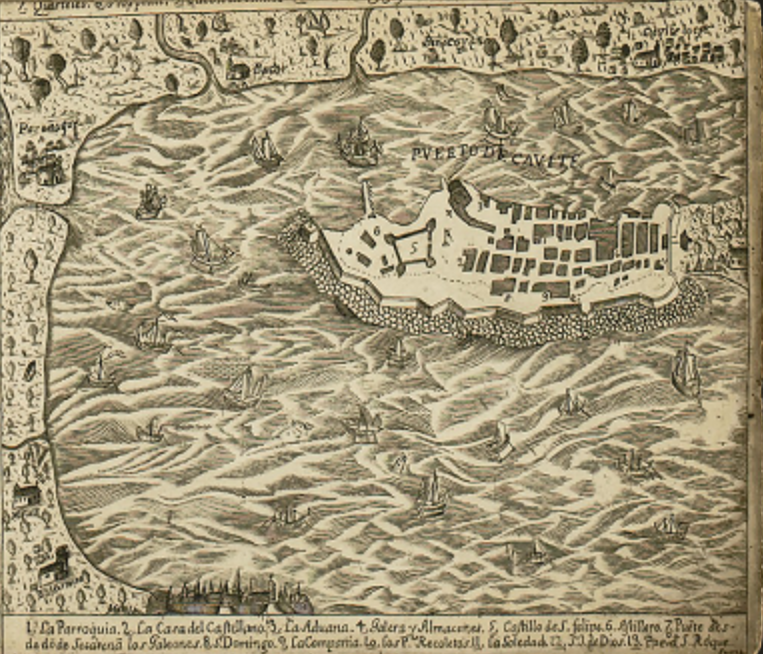
Quadrant D24 – Puerto de Cavite on the Murillo Velarde 1734 Map
The D24 quadrant of the Murillo Velarde 1734 map features Puerto de Cavite, the Spanish naval and shipbuilding base in the Philippines during the colonial period. This highly detailed depiction of the port highlights its fortifications, ship traffic, and surrounding settlements, showcasing its crucial role in the Galleon Trade and Spanish colonial defense.
-
Puerto de Cavite (Port of Cavite)
-
The fortified port is depicted with thick walls and bastions, indicating its strategic military importance.
-
The structure is labeled with numbers corresponding to key buildings, including churches, government offices, and warehouses.
-
Galleons and Other Vessels
-
Numerous Spanish ships (galleons and smaller boats) are visible in the bay, emphasizing Cavite’s role as a shipbuilding and repair hub.
-
Ships are seen arriving and departing, representing its function in the Manila-Acapulco Galleon Trade.
-
Defensive Fortifications
-
The Castillo de San Felipe is prominently marked, one of the main Spanish forts guarding Manila Bay.
-
These defenses were essential against Dutch, British, and Moro raids.
-
Customs House and Storage Facilities
-
Buildings labeled "Aduana" (Customs House) and "Almacenes" (Warehouses) highlight Cavite’s role as a trade center.
-
Goods from Mexico, China, and Southeast Asia were processed here before reaching Intramuros, Manila.
-
Churches and Religious Institutions
-
Surrounding Settlements
Historical Significance of Puerto de Cavite
-
Manila-Acapulco Galleon Trade Hub
-
Cavite was the shipyard where galleons were built, repaired, and outfitted for their trans-Pacific voyages.
-
The trade route connected Asia, the Americas, and Europe, bringing wealth and goods to Spain.
-
Military Stronghold Against Foreign Invasions
-
The Dutch attempted to seize Cavite in the 1600s, but Spanish forces successfully defended it.
-
In 1762, the British captured Cavite during their occupation of Manila in the Seven Years' War.
-
Cultural and Economic Impact
-
Cavite attracted Chinese, Mexican, and Filipino workers, making it a melting pot of cultures.
-
The port was one of the busiest in the Philippines, supplying Intramuros and the Spanish navy.
Puerto de Cavite was one of the most critical ports in the Spanish East Indies, serving as a military base, shipyard, and economic hub. The detailed depiction in Quadrant D24 of the Murillo Velarde map highlights its fortifications, bustling trade, and key role in Spanish colonial rule.
Sorry, no results matching your search criteria were found.
Locations
This is a primary location.